Entry Points:

About Ramah
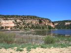
Ramah is a small ranching community located in the highlands of western New Mexico at the lofty elevation of 6,900 feet above sea level. It is located in Ramah Valley, a modestly-sized valley surrounded by gently sloping, forested hills. To the east and north the hills rise to elevations around 7,700 feet where they end at the brink of thousand-foot cliffs. Cliff-lined canyons cut into these hills, including especially the one occupied by Ramah Reservoir, built on Cebolla Creek.
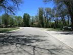
Ramah boasted a population of 407 people as of the year 2000. The town is laid out in a grid of about three streets in each direction on a north-south axis, lined mostly with neat, traditional homes built many years ago. Many tall, deciduous trees grow throughout the town. Ramah has a large Mormon population, which was no doubt a factor in its settlement. Native Americans also are common in the area and the Zuni Indian Reservation reaches to within a few miles of Ramah.
New Mexico Highway 53 passes through Ramah. There are few other towns for many miles in every direction, although many people live scattered throughout the surrounding rural areas.
Street Index
|
a road a street a trail Ashcroft Street Bloomfield Avenue |
Clawson Avenue Davis Street Lewis Street McNiel Street Poko Drive |
Ramah Lake Access Savoya Drive State Highway 53 Tietjen Avenue |