Entry Points:


About New Mexico
New Mexico became the 47th state of the union on January 6, 1912, with 121,665 square miles of the southwest deserts and mountains. Being the fifth largest state in land area, it has a population of 2,499,481 (in 2008), making it one of the smaller states in population (35th).
Prior to becoming a state, New Mexico had been a territory since 1850. Although it was mostly unsettled and both the United States and Mexico were anxious to get control of it, Mexico had claimed it since colonial times. At the end of the Mexican-American war, it and much of the American Southwest was ceded to the United States. The southernmost part of the state was acquired in 1853 as part of the Gadsden Purchase.
What to See in New Mexico
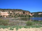
The San Francisco Mountains lie on the western border of New Mexico, with Escudilla Mountain reaching 10,912 feet. U.S. Highway 180 passes right through the San Francisco Mountains, visiting rustic towns like Reserve and Luna. Mountainous highlands surround the Zuni Indian Reservation, along state highways 53 and 602. The area is forested in juniper and cedar trees, with flat-topped mesas ending in colorful cliffs. Zuni Pueblo is an Indian town established hundreds of years ago before the European colonization. Ramah was settled Mormon pioneers. Reserve was once the the home of bandits of wild-west style shootouts. Historic Route 66 passes through New Mexico.
New Mexico Geography
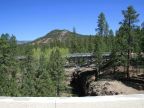
New Mexico lies at the southern end of the Rocky Mountains, the major mountain range of North America which extends northward into Canada. Most of the state is quite high in elevation, the lowest point being at 2,842 feet where the Pecos River flows into Texas. The highest point is Wheeler Peak, at a lofty 13,161 feet, being located in the Sangre de Christo Mountains in the north part of the state. A large area of the mountains in the north part of the state are above 10,000 feet. The Great Plains cover the eastern portion of New Mexico. A great desert basin fills much of the northwest corner.
Texas borders New Mexico on the south and east, Colorado on the north, and Arizona on the west. A small bit of Oklahoma borders it at the northeast corner, and Mexico borders it along the west end of the south border. Utah borders it at the northwest corner, known as Four Corners, the only place in America where the borders of four states come to a corner. Interstate 25 travels north and south through the middle of New Mexico, following the Rio Grande most of the way. Interstate crosses east-west through the state, and the two meet at Albuquerque, the largest city. Interstate 10 passes through the southwest corner of the state.
For More Information:
See Wikipedia's New Mexico page.
|
|