Entry Points:

About Quemado
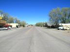
Quemado is a cowboy-style ranching town sitting in the highland plains of New Mexico, dozens of miles from any towns of any significant size. It is in a valley overlooked by flat-topped mesas in the distance on the south and the west. Largo Creek, a dry wash, runs past the west side of town. To the north are some low hills, decorated by colorful rocky outcroppings.
The name Quemado is the Spanish word for “burned”, referring to the volcanic activity of the area in geologic history. It was settled by sheepherder José Antonio Padilla in 1880, and has been famous for its rodeo celebrities who lived in nearby Largo Canyon.
Quemado is unincorporated and no official population is available, but it would be a hundred or so. U.S. Highway 60 passes east-west through Quemado, leading to Springerville to the west, and Magdalena to the east. New Mexico Highways 32, 36 and 601 all begin at Quemado. Highway 32 heads south to Apache Creek. Highway 36 heads north, and Highway 601 is a little-used route heading northwest towards Zuni Salt Lake, which is only paved for the first mile.
Street Index
|
a road Baca Street Candelaria Street Fifth Street First Street |
Fourth Street Lopez Street Second Street State Highway 32 State Highway 36 |
State Highway 601 Third Street U.S. Highway 60 |